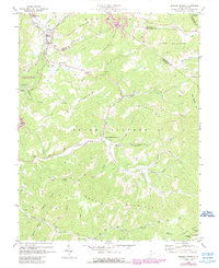
1969 Map of Meadow Bridge
USGS Topo · Published 1989About this map
Meadow Bridge serves as the focal point of this 1969 topographic study, situated along the upper reaches of Meadow Creek where the boundaries of Fayette, Greenbrier, and Summers counties converge. The landscape is defined by the high ridges of Patterson Mountain and Wallohole Mountain, separating small farming and residential pockets like Green Sulphur Springs and Lockbridge. Cultural life in these hollows is anchored by numerous country churches, including Little Meadow Ch, Lane Ch, and Mountain View Ch, alongside a notable mid-century Drive-in Theater west of Coon Creek. While the terrain is dominated by peaks like Beelick Knob and Hump Mtn, the inclusion of the New River Gorge National River boundary reflects the transition of this area toward conservation and recreation during the late 1960s.
Find a feature on this map
53 named features on this map. Tap any name to fly to it.
Don’t see what you’re looking for? This feature index may not catch every label — zoom into the map to look around manually.
Map Details
Editions of this 1969 Meadow Bridge Map
3 editions found
Other maps of this area

1887 · Hinton
USGS Topo · 1:125,000

1892 · Hinton
USGS Topo · 1:125,000

1912 · Meadow Creek
USGS Topo · 1:48,000

1912 · Big Bend
USGS Topo · 1:62,500

1914 · Big Bend
USGS Topo · 1:62,500

1915 · Meadow Creek
USGS Topo · 1:62,500

1921 · Alderson
USGS Topo · 1:48,000

1921 · Clintonville
USGS Topo · 1:48,000

1923 · Clintonville
USGS Topo · 1:62,500
1923 · Alderson
USGS Topo · 1:62,500