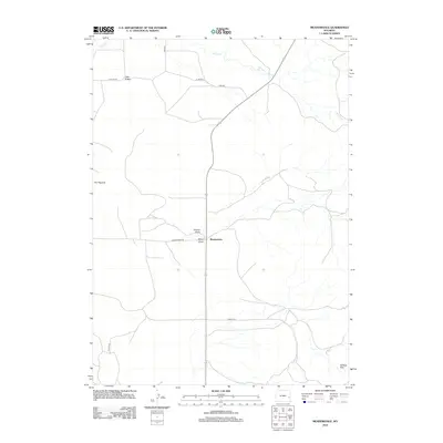
2012 Map of Meadowdale
USGS Topo · Published 2012About this map
Meadowdale serves as the central point of reference in this part of Platte County, where the high plains landscape is defined by its drainage systems and distinct relief. The terrain is marked by significant topographical landmarks such as The Hogback and the Wildcat Hills, while water resources like Willow Cr wind through the northern sections of the sheet. This area is characterized by a sparse, ranching-oriented settlement pattern connected by a network of rural routes including Meadowdale Rd and CO Hwy 270. Interpretive details like Vincent Draw and Miller Draw show how the local geography has been shaped by seasonal water runoff, which is critical for understanding the land use and historical development of this Wyoming interior. The map also identifies specific local identifiers like Little Flattop and Jireh Rd, offering clear points of orientation within this expansive territory.
Find a feature on this map
12 named features on this map. Tap any name to fly to it.
Don’t see what you’re looking for? This feature index may not catch every label — zoom into the map to look around manually.
Map Details
Editions of this 2012 Meadowdale Map
This is the sole edition of this map. No revisions or reprints were ever made.
Other maps of this area

1896 · Hartville
USGS Topo · 1:125,000

1901 · Hartville
USGS Topo · 1:125,000

1949 · Cedar Top
USGS Topo · 1:24,000

1950 · Cedar Top
USGS Topo · 1:24,000

1950 · Prairie View School
USGS Topo · 1:24,000

1950 · Haushar Ranch
USGS Topo · 1:24,000

1950 · Hell Gap
USGS Topo · 1:24,000

1951 · Haushar Ranch
USGS Topo · 1:24,000
1951 · Hell Gap
USGS Topo · 1:24,000

1951 · Moore Spring
USGS Topo · 1:24,000