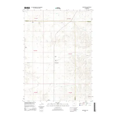
2015 Map of Meadowdale
USGS Topo · Published 2015About this map
Meadowdale sits at the center of this high-plains landscape, where the borders of Platte, Niobrara, and Goshen counties meet. The terrain is defined by a series of named drainages including Vincent Draw and Miller Draw, which cut through the open country toward Willow Cr in the north. To the west, the prominent ridge of The Hogback and the elevation of Little Flattop provide significant local landmarks. The area is interlaced with rural routes such as Jireh Rd, Meadowdale Rd, and CR-270, which connect isolated ranching homesteads across the townships. In the south, the map reaches the northern edge of the Wildcat Hills near Grant Agnew Draw, illustrating a transitional cattle-country topography where traditional land-survey sections remain the primary structural framework for the region's geography.
Find a feature on this map
23 named features on this map. Tap any name to fly to it.
Don’t see what you’re looking for? This feature index may not catch every label — zoom into the map to look around manually.
Map Details
Editions of this 2015 Meadowdale Map
This is the sole edition of this map. No revisions or reprints were ever made.
Other maps of this area

1896 · Hartville
USGS Topo · 1:125,000

1901 · Hartville
USGS Topo · 1:125,000

1949 · Cedar Top
USGS Topo · 1:24,000

1950 · Cedar Top
USGS Topo · 1:24,000

1950 · Prairie View School
USGS Topo · 1:24,000

1950 · Haushar Ranch
USGS Topo · 1:24,000

1950 · Hell Gap
USGS Topo · 1:24,000

1951 · Haushar Ranch
USGS Topo · 1:24,000
1951 · Hell Gap
USGS Topo · 1:24,000

1951 · Moore Spring
USGS Topo · 1:24,000