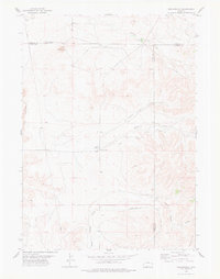
1978 Map of Meadowdale
USGS Topo · Published 1978About this map
Meadowdale and its surrounding high plains landscape sit at a tri-county junction in eastern Wyoming. This 1978 survey highlights the intersection of the Niobrara, Platte, and Goshen county lines, capturing a ranching and energy landscape before significant modern modernization. The terrain is defined by dramatic geological features like The Hogback and Flattop, while the drainage system of Vincent Draw and Agnew Draw dictates the flow of the local topography. Human presence is marked by sparse infrastructure, including a prominent Pipeline, numerous Wells, and a functional Landing Strip. The inclusion of the Rodeo Ground and the Jireh Road corridor provides evidence of the social and transit focal points for this rural community during the late 1970s.
Find a feature on this map
20 named features on this map. Tap any name to fly to it.
Don’t see what you’re looking for? This feature index may not catch every label — zoom into the map to look around manually.
Map Details
Editions of this 1978 Meadowdale Map
This is the sole edition of this map. No revisions or reprints were ever made.
Other maps of this area

1896 · Hartville
USGS Topo · 1:125,000

1901 · Hartville
USGS Topo · 1:125,000

1949 · Cedar Top
USGS Topo · 1:24,000

1950 · Cedar Top
USGS Topo · 1:24,000

1950 · Prairie View School
USGS Topo · 1:24,000

1950 · Haushar Ranch
USGS Topo · 1:24,000

1950 · Hell Gap
USGS Topo · 1:24,000

1951 · Haushar Ranch
USGS Topo · 1:24,000
1951 · Hell Gap
USGS Topo · 1:24,000

1951 · Moore Spring
USGS Topo · 1:24,000