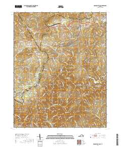
2019 Map of Meadows of Dan
USGS Topo · Published 2019About this map
The Dan River carves a deep path through this section of the Blue Ridge, anchored by the iconic Mabry Mill in the northeastern corner. This 2019 survey documents the complex topography where the plateau drops toward Kibler Valley, revealing the dramatic landforms of the Pinnacles of Dan and Great Falls of Dan. The landscape is a mix of high-altitude agricultural clearings and steep wooded slopes, with the Blue Ridge Parkway tracing the high ground near Pike City. For genealogists, the map is remarkably dense with family-named burial sites, including the Sollie Alderman Cem, Terry Barnard Cem, and Emmitt D Stanley Cem. These small family plots, scattered from the banks of Big Reed Island Cr to the heights of Greene Knob, provide a precise spatial record of the multi-generational settlement patterns in this part of Patrick and Carroll Counties.
Find a feature on this map
82 named features on this map. Tap any name to fly to it.
Don’t see what you’re looking for? This feature index may not catch every label — zoom into the map to look around manually.
Map Details
Editions of this 2019 Meadows of Dan Map
This is the sole edition of this map. No revisions or reprints were ever made.
Other maps of this area

1889 · Hillsville
USGS Topo · 1:125,000

1892 · Hillsville
USGS Topo · 1:125,000

1896 · Hillsville
USGS Topo · 1:125,000

1928 · Stuart
USGS Topo · 1:48,000

1931 · Stuart
USGS Topo · 1:62,500

1953 · Winston-Salem
USGS Topo · 1:250,000

1955 · Winston-Salem
USGS Topo · 1:250,000

1956 · Macks Mountain
USGS Topo · 1:62,500

1957 · Mount Airy
USGS Topo · 1:62,500

1957 · Floyd
USGS Topo · 1:62,500