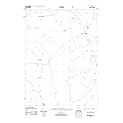
2011 Map of Meadowville
USGS Topo · Published 2011About this map
Meadowville lies at the junction of several canyon systems in Rich County, where Meadowville Creek and Cheney Creek drain the surrounding uplands. This 2011 survey illustrates a landscape of high-altitude flats and deep drainages, including Lone Pine Flat and Jebo Flats, which historically supported ranching operations like the Cook Ranch near Cook Reservoir. The settlement pattern follows the canyon floors, with Temple Canyon Rd and Meadowville Rd providing the primary access through the varied terrain of Log Cabin Ridge and Slideout Canyon.
Find a feature on this map
39 named features on this map. Tap any name to fly to it.
Don’t see what you’re looking for? This feature index may not catch every label — zoom into the map to look around manually.
Map Details
Editions of this 2011 Meadowville Map
This is the sole edition of this map. No revisions or reprints were ever made.
Other maps of this area

1912 · Randolph
USGS Topo · 1:125,000

1914 · Logan
USGS Topo · 1:125,000

1916 · Logan
USGS Topo · 1:125,000

1949 · Boulter Mts
USGS Topo · 1:24,000

1954 · Ogden
USGS Topo · 1:250,000

1958 · Ogden
USGS Topo · 1:250,000

1960 · Ogden
USGS Topo · 1:250,000
1969 · Tony Grove Creek
USGS Topo · 1:24,000

1969 · Boulder Mtn
USGS Topo · 1:24,000
1969 · Red Spur Mtn
USGS Topo · 1:24,000