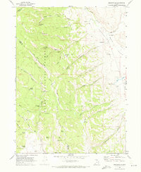
1969 Map of Meadowville
USGS Topo · Published 1973About this map
Meadowville serves as the quiet center of this high-elevation landscape in Rich Co and Cache Co, Utah. The small settlement is situated at the edge of the Meadowville Valley, characterized by its proximity to the Cache National Forest boundary. The topography is defined by complex drainage systems and steep ridgelines, such as Log Cabin Ridge, which separates Log Cabin Hollow from the deep folds of the forest. Numerous springs, including Government Spring, Suck Spring, and Nebeker Spring, dot the canyons, reflecting a landscape where water sources were critical for ranching and local survival.
Find a feature on this map
47 named features on this map. Tap any name to fly to it.
Don’t see what you’re looking for? This feature index may not catch every label — zoom into the map to look around manually.
Map Details
Editions of this 1969 Meadowville Map
This is the sole edition of this map. No revisions or reprints were ever made.
Other maps of this area

1912 · Randolph
USGS Topo · 1:125,000

1914 · Logan
USGS Topo · 1:125,000

1916 · Logan
USGS Topo · 1:125,000

1949 · Boulter Mts
USGS Topo · 1:24,000

1954 · Ogden
USGS Topo · 1:250,000

1958 · Ogden
USGS Topo · 1:250,000

1960 · Ogden
USGS Topo · 1:250,000
1969 · Tony Grove Creek
USGS Topo · 1:24,000

1969 · Boulder Mtn
USGS Topo · 1:24,000
1969 · Red Spur Mtn
USGS Topo · 1:24,000