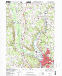
1998 Map of Meadville
USGS Topo · Published 1999About this map
French Creek winds through the heart of Crawford County, carving a valley that anchors the industrial and educational center of Meadville. By the late 20th century, the landscape reflects a complex transition from its early mill-town roots to a regional hub, evidenced by the sprawling campus of Allegheny College and significant medical facilities like Spencer Hospital and City Hospital. The map details the dense urban grid of the city proper, including the Court House and multiple historic schools such as Smock Memorial Sch, while highlighting the surrounding rural character through numerous family-named landmarks like Blacks Corner and Coons Corners.
Find a feature on this map
73 named features on this map. Tap any name to fly to it.
Don’t see what you’re looking for? This feature index may not catch every label — zoom into the map to look around manually.
Map Details
Editions of this 1998 Meadville Map
This is the sole edition of this map. No revisions or reprints were ever made.
Other maps of this area

1900 · Girard
USGS Topo · 1:62,500

1906 · Linesville
USGS Topo · 1:62,500

1908 · Linesville
USGS Topo · 1:62,500

1923 · Meadville
USGS Topo · 1:62,500

1923 · Cambridge Springs
USGS Topo · 1:62,500

1925 · Meadville
USGS Topo · 1:62,500

1925 · Cambridge Springs
USGS Topo · 1:62,500

1943 · Meadville
USGS Topo · 1:62,500

1943 · Cambridge Springs
USGS Topo · 1:62,500

1950 · Cleveland
USGS Topo · 1:250,000