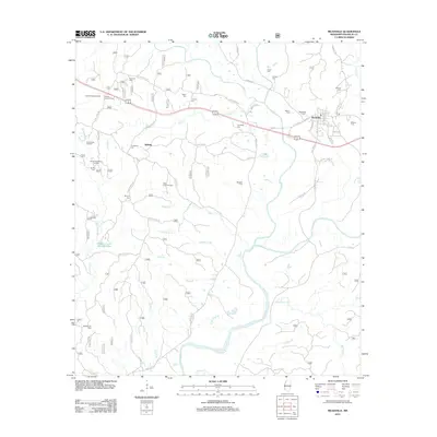
2012 Map of Meadville
USGS Topo · Published 2012About this map
The Homochitto River and its Middle Fork dominate this 2012 survey of Franklin County, Mississippi. Centered on the town of Meadville, the landscape shows a distinctive blend of timber management and energy extraction. Numerous active petroleum sites, including the Kirby Oil Field and the South Providence Oil Field, are scattered across the terrain, indicating the continued economic importance of the local oil industry.
Find a feature on this map
69 named features on this map. Tap any name to fly to it.
Don’t see what you’re looking for? This feature index may not catch every label — zoom into the map to look around manually.
Map Details
Editions of this 2012 Meadville Map
This is the sole edition of this map. No revisions or reprints were ever made.
Other maps of this area

1953 · Natchez
USGS Topo · 1:250,000

1956 · Natchez
USGS Topo · 1:250,000

1959 · Natchez
USGS Topo · 1:250,000

1961 · Crosby
USGS Topo · 1:62,500

1962 · Fayette
USGS Topo · 1:62,500

1962 · Bude
USGS Topo · 1:62,500

1963 · Union Church
USGS Topo · 1:62,500
1984 · Natchez
USGS Topo · 1:100,000

1984 · Brookhaven
USGS Topo · 1:100,000

1984 · McComb
USGS Topo · 1:100,000