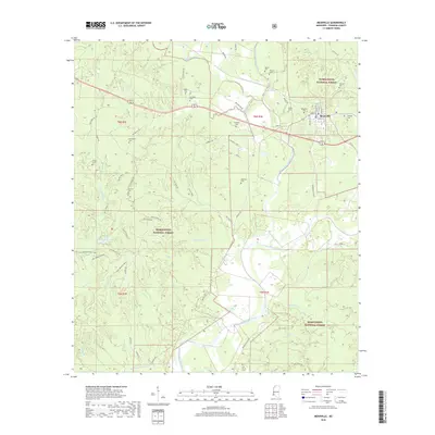
2018 Map of Meadville
USGS Topo · Published 2018About this map
Meadville serves as the focal point of this Mississippi landscape, situated at the junction of the Middle Fork Homochitto River and the main Homochitto River. The town is surrounded by the dense woodlands of the Homochitto National Forest, where a network of trails and roads such as Tallys Trail and Wagon Wheel Rd weave through the timberland. The map provides significant genealogical value, documenting numerous family and community burial sites like Meadville Cem, Providence Cem, Moore Cem, and Smyrna Cem scattered across the rural township lines.
Find a feature on this map
65 named features on this map. Tap any name to fly to it.
Don’t see what you’re looking for? This feature index may not catch every label — zoom into the map to look around manually.
Map Details
Editions of this 2018 Meadville Map
This is the sole edition of this map. No revisions or reprints were ever made.
Other maps of this area

1953 · Natchez
USGS Topo · 1:250,000

1956 · Natchez
USGS Topo · 1:250,000

1959 · Natchez
USGS Topo · 1:250,000

1961 · Crosby
USGS Topo · 1:62,500

1962 · Fayette
USGS Topo · 1:62,500

1962 · Bude
USGS Topo · 1:62,500

1963 · Union Church
USGS Topo · 1:62,500
1984 · Natchez
USGS Topo · 1:100,000

1984 · Brookhaven
USGS Topo · 1:100,000

1984 · McComb
USGS Topo · 1:100,000