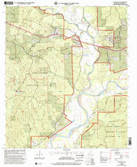
2000 Map of Meadville
USGS Topo · Published 2002About this map
Meadville serves as the focal point of this late-twentieth-century study, situated at the edge of the Homochitto National Forest. The landscape is defined by the winding course of the Middle Fork Homochitto River and its numerous tributaries, including Owen Creek and Tally Creek. The map reveals a dispersed rural layout of small family burial grounds and community centers, such as Moore Cem and Providence Ch, scattered among the timberlands. An established Oil Field west of the river signifies the region's industrial footprint amidst the forest. Further south, the Homochitto Wildlife Management Area borders the river, where creek branches like Grass Patch Branch and Grisham Branch feed into the main waterway. The presence of the Franklin County Hospital and Whittington Roadside Park marks the civic development of the area as it stood at the millennium.
Find a feature on this map
48 named features on this map. Tap any name to fly to it.
Don’t see what you’re looking for? This feature index may not catch every label — zoom into the map to look around manually.
Map Details
Editions of this 2000 Meadville Map
This is the sole edition of this map. No revisions or reprints were ever made.
Other maps of this area

1953 · Natchez
USGS Topo · 1:250,000

1956 · Natchez
USGS Topo · 1:250,000

1959 · Natchez
USGS Topo · 1:250,000

1961 · Crosby
USGS Topo · 1:62,500

1962 · Fayette
USGS Topo · 1:62,500

1962 · Bude
USGS Topo · 1:62,500

1963 · Union Church
USGS Topo · 1:62,500
1984 · Natchez
USGS Topo · 1:100,000

1984 · Brookhaven
USGS Topo · 1:100,000

1984 · McComb
USGS Topo · 1:100,000