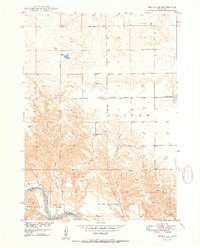
1950 Map of Meadville
USGS Topo · Published 1950About this map
The Niobrara River defines the southern boundary of this Nebraska landscape, where the Keya Paha Co Brown Co line crosses the water near the settlement of Meadville. This 1950 survey, conducted as part of the Missouri River Basin development program, shows a rural district organized around a network of one-room schoolhouses. Notable educational landmarks include School No 90, School No 37, School No 57, and School No 42, which served the surrounding agricultural townships of Custer and Garfield. In the northeast, the outskirts of Springview are visible, while the terrain is deeply dissected by drainage systems like Rock Creek and Jewett Creek that flow south toward the Niobrara. The map provides a detailed view of mid-century rural infrastructure, including numerous windmills and a complex system of section-line roads.
Find a feature on this map
13 named features on this map. Tap any name to fly to it.
Don’t see what you’re looking for? This feature index may not catch every label — zoom into the map to look around manually.
Map Details
Editions of this 1950 Meadville Map
2 editions found
Other maps of this area

1949 · Dutch Creek
USGS Topo · 1:24,000

1950 · Bassett NW
USGS Topo · 1:24,000

1950 · Meadville
USGS Topo · 1:24,000

1950 · Huddle Table
USGS Topo · 1:24,000

1950 · Dutch Creek
USGS Topo · 1:24,000

1954 · Ainsworth NW
USGS Topo · 1:24,000

1955 · O'Neill
USGS Topo · 1:250,000

1959 · O'Neill
USGS Topo · 1:250,000
1964 · Meadville NW
USGS Topo · 1:24,000
1964 · Springview
USGS Topo · 1:24,000