
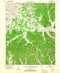
1952 Map of Means
USGS Topo · Published 1953About this map
Jeffersonville and Means serve as the primary hubs of this early 1950s landscape, where the agricultural valleys of Slate Creek transition into the dense ridgelines of the Cumberland National Forest. The map reveals a community structured around small rural centers like Lucky Stop and Old Salem, supported by numerous local institutions such as Easter Ch, Pine-Hill Ch, and the Willoughby Sch.
Find a feature on this map
70 named features on this map. Tap any name to fly to it.
Don’t see what you’re looking for? This feature index may not catch every label — zoom into the map to look around manually.
Map Details
Editions of this 1952 Means Map
2 editions found
Other maps of this area

1892 · Beattyville
USGS Topo · 1:125,000

1929 · Salt Lick
USGS Topo · 1:62,500

1934 · Salt Lick
USGS Topo · 1:62,500

1950 · Levee
USGS Topo · 1:24,000

1952 · Preston
USGS Topo · 1:24,000

1952 · Clay City
USGS Topo · 1:24,000

1952 · Mount Sterling
USGS Topo · 1:24,000

1952 · Frenchburg
USGS Topo · 1:24,000

1952 · Stanton
USGS Topo · 1:24,000

1952 · Levee
USGS Topo · 1:24,000