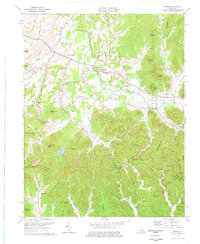
1975 Map of Means
USGS Topo · Published 1977About this map
Jeffersonville and Means serve as the primary hubs of this landscape during the mid-1970s, situated where the rolling terrain of Montgomery County meets the steep elevations of the Daniel Boone National Forest. The transition from cleared farmland to dense timber is marked by several high points, including Big Round Mtn and Kashs Knob. Local life is anchored by country churches like Old Salem Ch and Easter Ch, while the region's educational history is noted at the Pine Hill Sch. The southern portion of the map is defined by a complex network of hollows and ridges, such as Gibson Hollow and Sand Mountain, which are dotted with numerous Gas Well sites and a Compressor Sta. This energy infrastructure, alongside the scenic Sid Calk Lake and geological landmarks like Chimney Rocks, illustrates a region where rural settlement, natural resources, and early conservation efforts coincide.
Find a feature on this map
75 named features on this map. Tap any name to fly to it.
Don’t see what you’re looking for? This feature index may not catch every label — zoom into the map to look around manually.
Map Details
Editions of this 1975 Means Map
This is the sole edition of this map. No revisions or reprints were ever made.
Other maps of this area

1892 · Beattyville
USGS Topo · 1:125,000

1929 · Salt Lick
USGS Topo · 1:62,500

1934 · Salt Lick
USGS Topo · 1:62,500

1950 · Levee
USGS Topo · 1:24,000

1952 · Preston
USGS Topo · 1:24,000

1952 · Clay City
USGS Topo · 1:24,000

1952 · Mount Sterling
USGS Topo · 1:24,000

1952 · Frenchburg
USGS Topo · 1:24,000

1952 · Stanton
USGS Topo · 1:24,000

1952 · Means
USGS Topo · 1:24,000