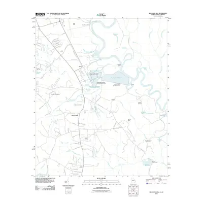
2011 Map of Mechanic Hill
USGS Topo · Published 2011About this map
The Savannah River winds along the border between Georgia and South Carolina, defining a landscape shaped by both industrial infrastructure and historical residential pockets. The Mechanic Hill area and the nearby Goshen Plantation represent local settlement patterns in the early 21st century, punctuated by numerous family and community burial sites such as Twiggs Cemetery, Union Cemetery, and Johnson Cemetery. Further south, Bennock Millpond and its associated dam reflect the local water management history of the region. This 2011 survey captures the area's transition into modern land use, featuring large-scale utilities like Wastewater Treatment Pond Number Five alongside recreation areas such as Camp Linwood Hayne. The map also details aviation infrastructure at Bush Field, illustrating the connectivity of this riverfront corridor.
Find a feature on this map
92 named features on this map. Tap any name to fly to it.
Don’t see what you’re looking for? This feature index may not catch every label — zoom into the map to look around manually.
Map Details
Editions of this 2011 Mechanic Hill Map
This is the sole edition of this map. No revisions or reprints were ever made.
Other maps of this area

1919 · Gough
USGS Topo · 1:62,500

1920 · Greens Cut
USGS Topo · 1:62,500

1921 · Augusta
USGS Topo · 1:62,500

1922 · Hephzibah
USGS Topo · 1:62,500

1943 · Greens Cut
USGS Topo · 1:62,500

1943 · Augusta East
USGS Topo · 1:125,000

1943 · Augusta
USGS Topo · 1:62,500

1948 · Hephzibah
USGS Topo · 1:62,500

1948 · Gough
USGS Topo · 1:62,500
1950 · Hephzibah
USGS Topo · 1:24,000