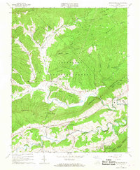
1965 Map of Mechanicsburg
USGS Topo · Published 1967About this map
Mechanicsburg sits at the heart of this mid-1960s study, where the terrain is defined by a series of prominent ridges and deep hollows. The settlement pattern follows the fertile valleys between Walker Mountain and Brushy Mountain, with small communities like Crandon and Holly Brook linked by winding valley roads. A unique industrial and institutional presence is found near the eastern edge, including the State Correctional Farm, a Filtration Plant, and a Sewage Disposal facility serving the local area.
Find a feature on this map
52 named features on this map. Tap any name to fly to it.
Don’t see what you’re looking for? This feature index may not catch every label — zoom into the map to look around manually.
Map Details
Editions of this 1965 Mechanicsburg Map
2 editions found
Other maps of this area

1887 · Pocahontas
USGS Topo · 1:125,000

1890 · Dublin
USGS Topo · 1:125,000

1891 · Pocahontas
USGS Topo · 1:125,000

1891 · Dublin
USGS Topo · 1:125,000

1894 · Pocahontas
USGS Topo · 1:125,000

1895 · Pocahontas
USGS Topo · 1:125,000

1913 · Peterstown
USGS Topo · 1:48,000

1913 · Bluefield
USGS Topo · 1:48,000

1916 · Bluefield
USGS Topo · 1:62,500

1916 · Peterstown
USGS Topo · 1:62,500