
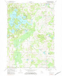
1964 Map of Mecosta
USGS Topo · Published 1965About this map
Remus and Mecosta anchor this mid-1960s map of central Michigan, illustrating a landscape defined by small-scale farming and the legacy of early transit. The Chesapeake and Ohio railroad runs through the eastern portion of the quadrangle, while an Old Railroad Grade traces a path further north, hinting at the evolving transportation infrastructure of the region. Local education and community life are marked by the presence of St Michael Sch and the Mecosta-Remus High Sch, alongside numerous gravel pits and gas wells that reflect the area's resource-based economy.
Find a feature on this map
38 named features on this map. Tap any name to fly to it.
Don’t see what you’re looking for? This feature index may not catch every label — zoom into the map to look around manually.
Map Details
Editions of this 1964 Mecosta Map
2 editions found
Other maps of this area

1954 · Midland
USGS Topo · 1:250,000

1958 · Midland
USGS Topo · 1:250,000

1958 · Big Rapids
USGS Topo · 1:62,500

1959 · Midland
USGS Topo · 1:250,000

1959 · Howard City
USGS Topo · 1:62,500

1964 · Edmore
USGS Topo · 1:24,000

1964 · Six Lakes
USGS Topo · 1:24,000

1964 · Mecosta NW
USGS Topo · 1:24,000

1964 · Blanchard
USGS Topo · 1:24,000

1964 · Sherman City
USGS Topo · 1:24,000