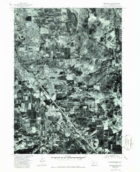
1974 Map of Medford East
USGS Topo · Published 1986About this map
Medford and Phoenix are captured in high-resolution detail through this 1974 orthophoto, providing an aerial view of Jackson County during a period of significant mid-century expansion. The photographic imagery reveals the precise layout of residential blocks, commercial corridors, and the surrounding agricultural landscape as it existed decades ago. To the east, the prominent terrain of Roxy Ann Peak overlooks the valley, marking the transition from the developing urban centers to the more rugged upland geography. This specific format offers researchers a more granular view of land use and property lines than a standard topographic line drawing, documenting the evolution of southern Oregon's urban and rural boundaries.
Find a feature on this map
3 named features on this map. Tap any name to fly to it.
Don’t see what you’re looking for? This feature index may not catch every label — zoom into the map to look around manually.
Map Details
Editions of this 1974 Medford East Map
2 editions found
Other maps of this area

1891 · Ashland
USGS Topo · 1:250,000

1893 · Ashland
USGS Topo · 1:250,000

1897 · Ashland
USGS Topo · 1:250,000

1938 · Medford
USGS Topo · 1:125,000

1954 · Medford
USGS Topo · 1:62,500

1954 · Lakecreek
USGS Topo · 1:62,500

1954 · Talent
USGS Topo · 1:62,500

1954 · Ashland
USGS Topo · 1:62,500

1955 · Medford
USGS Topo · 1:250,000

1957 · Medford
USGS Topo · 1:250,000