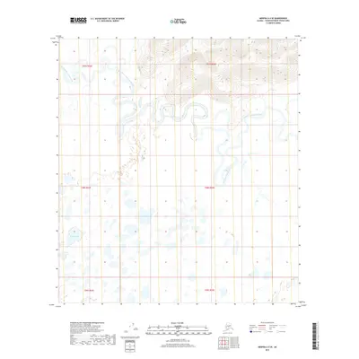
2019 Map of Medfra A-3 SE
USGS Topo · Published 2019About this map
The East Fork Kuskokwim River dominates this interior Alaska landscape, characterized by complex meanders and oxbow formations as it winds through the Unorganized Borough. This 2019 survey captures a transition between the elevated topography in the northeast and the marshy lowlands of the south. The southern half of the quadrangle is defined by a dense network of wetlands and standing water, including the distinctively named Fish Lake and Round Lake. Small tributaries like Jones Cr feed into the primary river system, reflecting a classic subarctic drainage pattern where the water's path is constantly reshaped by seasonal shifts. The map provides a detailed view of the township and range divisions, such as t28s r25e, in a region largely devoid of man-made infrastructure or road networks.
Find a feature on this map
10 named features on this map. Tap any name to fly to it.
Don’t see what you’re looking for? This feature index may not catch every label — zoom into the map to look around manually.
Map Details
Editions of this 2019 Medfra A-3 SE Map
This is the sole edition of this map. No revisions or reprints were ever made.
Other maps of this area

1949 · McGrath
USGS Topo · 1:250,000

1950 · Medfra
USGS Topo · 1:250,000

1950 · McGrath
USGS Topo · 1:250,000

1954 · McGrath D-3
USGS Topo · 1:63,360

1954 · Medfra A-3
USGS Topo · 1:63,360

1958 · McGrath D-2
USGS Topo · 1:63,360

1958 · Medfra A-2
USGS Topo · 1:63,360

1958 · McGrath
USGS Topo · 1:250,000

1959 · Medfra
USGS Topo · 1:250,000
2019 · McGrath D-2 NW
USGS Topo · 1:25,000