
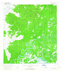
1955 Map of Medfra B-3
USGS Topo · Published 1963About this map
The North Fork Kuskokwim River anchors the southeastern corner of this Interior Alaska landscape, where it meets the Slow Fork. This mid-century topography reveals a complex drainage network characteristic of the Yukon-Koyukuk region, featuring the meandering paths of Soda Creek and Whirlwind Creek. The terrain is defined by the significant elevation changes around Nixon Fk, which separates various creek systems. Smaller water bodies like Berry Lake provide specific landmarks in an otherwise wilderness-dominated area. This survey reflects the region's state in the 1950s, a period when the U.S. Geological Survey relied on photogrammetric methods from 1953-1955 aerial photography to document these remote watersheds and unnamed ridges before more modern infrastructure arrived.
Find a feature on this map
9 named features on this map. Tap any name to fly to it.
Don’t see what you’re looking for? This feature index may not catch every label — zoom into the map to look around manually.
Map Details
Editions of this 1955 Medfra B-3 Map
This is the sole edition of this map. No revisions or reprints were ever made.
Other maps of this area

1950 · Medfra
USGS Topo · 1:250,000

1953 · Medfra B-4
USGS Topo · 1:63,360

1953 · Medfra C-4
USGS Topo · 1:63,360

1954 · Medfra C-3
USGS Topo · 1:63,360

1954 · Medfra A-3
USGS Topo · 1:63,360

1958 · Medfra A-2
USGS Topo · 1:63,360

1958 · Medfra C-2
USGS Topo · 1:63,360

1958 · Medfra B-2
USGS Topo · 1:63,360
1959 · Medfra A-4
USGS Topo · 1:63,360

1959 · Medfra
USGS Topo · 1:250,000