
1953 Map of Medfra B-4
USGS Topo · Published 1964About this map
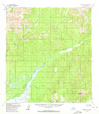
The Nixon Fork meanders through the heart of this Alaskan interior landscape, a region defined in the early 1950s by its drainage systems and isolated peaks. To the northwest, the Sunshine Mountains dominate the horizon, while the southern reaches of the quadrangle are anchored by prominent landmarks like Limestone Mountain, Strand Peak, and Jumbo Peak. The map illustrates an intricate web of waterways, including Clearwater Creek, Meadow Creek, and Cottonwood Creek, which feed into the primary river system.
Find a feature on this map
18 named features on this map. Tap any name to fly to it.
Don’t see what you’re looking for? This feature index may not catch every label — zoom into the map to look around manually.
Map Details
Editions of this 1953 Medfra B-4 Map
2 editions found
Other maps of this area

1950 · Medfra
USGS Topo · 1:250,000

1953 · Medfra B-5
USGS Topo · 1:63,360

1953 · Medfra C-4
USGS Topo · 1:63,360

1954 · Medfra A-5
USGS Topo · 1:63,360

1954 · Medfra C-5
USGS Topo · 1:63,360

1954 · Medfra C-3
USGS Topo · 1:63,360

1954 · Medfra A-3
USGS Topo · 1:63,360

1955 · Medfra B-3
USGS Topo · 1:63,360
1959 · Medfra A-4
USGS Topo · 1:63,360

1959 · Medfra
USGS Topo · 1:250,000