
1954 Map of Medfra A-5
USGS Topo · Published 1958About this map
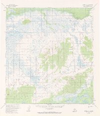
The Kuskokwim River snakes across the southern portion of this mid-century Alaskan interior landscape, a primary waterway in a region dominated by vast drainage networks and isolated peaks. This 1954 survey, compiled from aerial photography, illustrates the complex hydrology of the Nixon River and its tributary, the Little Nixon River, which feed into the surrounding marshlands. High ground is marked by prominent landmarks such as Halfway Mountain and Appel Mtn, alongside the singular peak identified simply as Alone. The map documents the intricate web of smaller watercourses, including Broken Snowshoe Creek, Wabash Creek, and Grayling Creek, which define the topography before the era of modern development. These features provide a look at the wilderness state of the Fourth Judicial Division during a period of extensive federal topographic mapping in the territory.
Find a feature on this map
13 named features on this map. Tap any name to fly to it.
Don’t see what you’re looking for? This feature index may not catch every label — zoom into the map to look around manually.
Map Details
Editions of this 1954 Medfra A-5 Map
3 editions found
Other maps of this area

1949 · McGrath
USGS Topo · 1:250,000

1950 · Medfra
USGS Topo · 1:250,000

1950 · McGrath
USGS Topo · 1:250,000

1953 · McGrath D-5
USGS Topo · 1:63,360

1953 · McGrath D-4
USGS Topo · 1:63,360

1953 · Medfra B-4
USGS Topo · 1:63,360

1953 · Medfra B-5
USGS Topo · 1:63,360

1954 · Medfra A-6
USGS Topo · 1:63,360

1954 · McGrath D-6
USGS Topo · 1:63,360

1954 · Medfra B-6
USGS Topo · 1:63,360