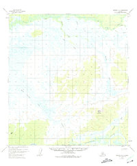
1954 Map of Medfra A-5
USGS Topo · Published 1975About this map
The Kuskokwim River anchors the southern boundary of this Alaskan interior landscape, where the winding watercourse and its tributaries define the remote terrain. This 1954 survey, based on aerial photography from the early 1950s, reveals a wilderness largely devoid of permanent human infrastructure, dominated instead by the complex drainage systems of the Nixon Fork and several named creeks. Elevated landmarks like Halfway Mountain and Alone serve as critical vertical control points for the U.S. Geological Survey in an era when land lines were predetermined but remained unsurveyed on the ground. The intricate networks of Broken Snowshoe Creek and Grayling Creek showcase the dense, marshy lowlands typical of the Yukon-Koyukuk region before more modern developments altered the access to these remote reaches.
Find a feature on this map
13 named features on this map. Tap any name to fly to it.
Don’t see what you’re looking for? This feature index may not catch every label — zoom into the map to look around manually.
Map Details
Editions of this 1954 Medfra A-5 Map
3 editions found
Other maps of this area

1949 · McGrath
USGS Topo · 1:250,000

1950 · Medfra
USGS Topo · 1:250,000

1950 · McGrath
USGS Topo · 1:250,000

1953 · McGrath D-5
USGS Topo · 1:63,360

1953 · McGrath D-4
USGS Topo · 1:63,360

1953 · Medfra B-4
USGS Topo · 1:63,360

1953 · Medfra B-5
USGS Topo · 1:63,360

1954 · Medfra A-6
USGS Topo · 1:63,360

1954 · McGrath D-6
USGS Topo · 1:63,360

1954 · Medfra A-5
USGS Topo · 1:63,360