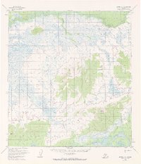
1954 Map of Medfra A-5
USGS Topo · Published 1972About this map
The Kuskokwim River defines the southern reaches of this interior Alaskan landscape, which was documented by the Geological Survey during the mid-1950s. The map illustrates a complex drainage system dominated by the Nixon Fork and its various tributaries, including Wabash Creek, Little Wabash Creek, and Clear Creek. These waterways thread through extensive low-lying wetlands, broken only by prominent terrain features such as Alone Mountain and Halfway Mountain. In the southwest corner, Appel Mtn stands near the Kuskokwim River, marking the transition between the river corridor and the surrounding hills. This survey relies on photogrammetric methods from aerial photography, capturing a moment when much of the land remained unsurveyed and unmarked according to the Bureau of Land Management records for the South Boundary Kateel River Meridian.
Find a feature on this map
12 named features on this map. Tap any name to fly to it.
Don’t see what you’re looking for? This feature index may not catch every label — zoom into the map to look around manually.
Map Details
Editions of this 1954 Medfra A-5 Map
3 editions found
Other maps of this area

1949 · McGrath
USGS Topo · 1:250,000

1950 · Medfra
USGS Topo · 1:250,000

1950 · McGrath
USGS Topo · 1:250,000

1953 · McGrath D-5
USGS Topo · 1:63,360

1953 · McGrath D-4
USGS Topo · 1:63,360

1953 · Medfra B-4
USGS Topo · 1:63,360

1953 · Medfra B-5
USGS Topo · 1:63,360

1954 · Medfra A-6
USGS Topo · 1:63,360

1954 · McGrath D-6
USGS Topo · 1:63,360

1954 · Medfra A-5
USGS Topo · 1:63,360