
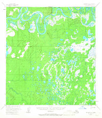
1953 Map of McGrath D-5
USGS Topo · Published 1958About this map
The Kuskokwim River defines the northern reaches of this interior landscape, exhibiting a complex series of oxbows and marshy lowlands typical of the region's riverine dynamics. A notable geographic feature, Stewart Bend, marks a sharp meander where the river shifts direction, surrounded by numerous unnamed ponds and wetlands. Small signs of human presence appear as isolated Cabins and a Cabin near the riverbanks, suggesting seasonal use or remote trapping outposts in the mid-1950s. To the south, the terrain transitions into a dense network of smaller waterways including Blackwater Creek and the Katlitna River, which drain the expansive, low-lying muskeg. Two triangulation stations, VABM Noir and VABM Kidney, provide the primary topographical reference points in an otherwise fluid environment of shifting streams and standing water.
Find a feature on this map
10 named features on this map. Tap any name to fly to it.
Don’t see what you’re looking for? This feature index may not catch every label — zoom into the map to look around manually.
Map Details
Editions of this 1953 McGrath D-5 Map
2 editions found
Other maps of this area

1949 · McGrath
USGS Topo · 1:250,000

1950 · Medfra
USGS Topo · 1:250,000

1950 · McGrath
USGS Topo · 1:250,000

1953 · McGrath C-4
USGS Topo · 1:63,360

1953 · McGrath D-4
USGS Topo · 1:63,360

1954 · Medfra A-6
USGS Topo · 1:63,360

1954 · McGrath D-6
USGS Topo · 1:63,360

1954 · Medfra A-5
USGS Topo · 1:63,360

1954 · McGrath C-6
USGS Topo · 1:63,360
1955 · McGrath C-5
USGS Topo · 1:63,360