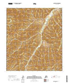
2019 Map of Medfra D-5 NW
USGS Topo · Published 2019About this map
S Fork Sulatna River winds through this interior Alaskan wilderness, following a serpentine path through the northern reaches of the Medfra D-5 NW quadrangle. The terrain is characterized by complex drainage patterns, where small tributaries like Timber Cr and Silver Cr feed into the larger river system. This topographic study, based on data from the U.S. Geological Survey, illustrates the undeveloped nature of the Yukon-Koyukuk Census Area in the early 21st century. The map focuses heavily on the natural relief and hydrography of the region, providing a baseline for environmental study and backcountry navigation in a landscape defined by its remote river valleys and high-elevation contours.
Find a feature on this map
8 named features on this map. Tap any name to fly to it.
Don’t see what you’re looking for? This feature index may not catch every label — zoom into the map to look around manually.
Map Details
Editions of this 2019 Medfra D-5 NW Map
This is the sole edition of this map. No revisions or reprints were ever made.
Other maps of this area

1950 · Medfra
USGS Topo · 1:250,000

1951 · Ruby
USGS Topo · 1:250,000

1952 · Ruby A-5
USGS Topo · 1:63,360

1952 · Ruby A-6
USGS Topo · 1:63,360

1952 · Ruby
USGS Topo · 1:250,000

1954 · Medfra D-5
USGS Topo · 1:63,360

1954 · Medfra D-6
USGS Topo · 1:63,360

1959 · Medfra
USGS Topo · 1:250,000

1964 · Ruby
USGS Topo · 1:250,000
2019 · Medfra D-6 NE
USGS Topo · 1:25,000