
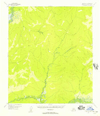
1954 Map of Medfra D-6
USGS Topo · Published 1963About this map
Poorman and a lone Cabin represent the sparse human footprint in this interior Alaskan wilderness during the mid-1950s. The landscape is defined by the complex, meandering waterway of the Innoko River and its North Fork, where the river splits into countless channels and seasonal wetlands. Movement across this remote terrain relied on seasonal pathways, including a Summer Trail and a Tractor Trail that navigate between the drainages of Silver Creek and Timber Creek. The cartography by the U.S. Geological Survey captures the raw hydrological patterns of the region, showing how the network of smaller tributaries like Tango Creek and Our Creek feed the main river system in a territory largely untouched by permanent road infrastructure.
Find a feature on this map
11 named features on this map. Tap any name to fly to it.
Don’t see what you’re looking for? This feature index may not catch every label — zoom into the map to look around manually.
Map Details
Editions of this 1954 Medfra D-6 Map
This is the sole edition of this map. No revisions or reprints were ever made.
Other maps of this area

1945 · Nulato
USGS Topo · 1:250,000

1950 · Medfra
USGS Topo · 1:250,000

1951 · Ophir
USGS Topo · 1:250,000

1951 · Nulato
USGS Topo · 1:250,000

1951 · Ruby
USGS Topo · 1:250,000

1952 · Ruby A-5
USGS Topo · 1:63,360

1952 · Ruby A-6
USGS Topo · 1:63,360
1952 · Nulato A-1
USGS Topo · 1:63,360

1952 · Nulato
USGS Topo · 1:250,000

1952 · Ruby
USGS Topo · 1:250,000