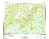
1959 Map of Medfra
USGS Topo · Published 1984About this map
The Kuskokwim River and its labyrinthine tributaries define this interior Alaskan landscape, where remote outposts like Medfra and Nicolai serve as anchors along the water. In the northern reaches, the Nowitna National Wildlife Refuge encompasses the headwaters of the Nowitna River, while the southern expanse is dominated by the Sunshine Mtns and the Sischu Mountains. The map reveals a reliance on aerial and seasonal transport, noted by the presence of the Medfra Landing Strip, the Colorado Creek Mine Landing Strip, and segments of a Winter Trail threading through the lowlands.
Find a feature on this map
120 named features on this map. Tap any name to fly to it.
Don’t see what you’re looking for? This feature index may not catch every label — zoom into the map to look around manually.
Map Details
Editions of this 1959 Medfra Map
3 editions found

Other maps of this area

1945 · Nulato
USGS Topo · 1:250,000

1948 · Kantishna River
USGS Topo · 1:250,000

1949 · McGrath
USGS Topo · 1:250,000

1950 · Medfra
USGS Topo · 1:250,000

1950 · McGrath
USGS Topo · 1:250,000

1950 · Talkeetna
USGS Topo · 1:250,000

1951 · Talkeetna
USGS Topo · 1:250,000

1951 · Ophir
USGS Topo · 1:250,000

1951 · Nulato
USGS Topo · 1:250,000

1951 · Kantishna River
USGS Topo · 1:250,000