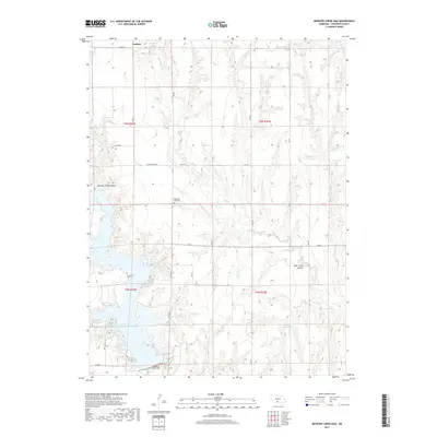
2017 Map of Medicine Creek Dam
USGS Topo · Published 2017About this map
Orafino sits at the northern edge of this Frontier County landscape, a region defined by the deep incisions of Mitchell Creek Canyon and Deer Creek Canyon into the Nebraska plains. The southern portion of the map is dominated by the waters of Harry Strunk Lake, held back by the prominent Medicine Creek Dam. This artificial reservoir and the smaller Druse Reservoir to the east represent the modern management of the Republican River basin's tributaries, such as Deer Cr and Muddy Cr. For those tracing local history, the map identifies rural markers including Hammond Cem near the lake shore and Pleasant View Cem situated further north. The network of secondary roads and trails, such as Lake Rd and several numbered routes, connects these points across a terrain characterized by complex drainage patterns and shifting elevations.
Find a feature on this map
30 named features on this map. Tap any name to fly to it.
Don’t see what you’re looking for? This feature index may not catch every label — zoom into the map to look around manually.
Map Details
Editions of this 2017 Medicine Creek Dam Map
This is the sole edition of this map. No revisions or reprints were ever made.
Other maps of this area

1902 · Gothenburg
USGS Topo · 1:125,000

1954 · McCook
USGS Topo · 1:250,000

1956 · Freedom
USGS Topo · 1:24,000

1956 · Cambridge
USGS Topo · 1:24,000

1956 · Medicine Creek Dam
USGS Topo · 1:24,000

1956 · Bartley
USGS Topo · 1:24,000

1956 · Stockville SE
USGS Topo · 1:24,000

1957 · McCook
USGS Topo · 1:250,000

1958 · McCook
USGS Topo · 1:250,000
1958 · Holbrook
USGS Topo · 1:24,000