
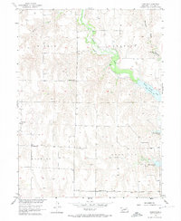
1956 Map of Freedom
USGS Topo · Published 1957About this map
Freedom serves as the quiet anchor for this rural landscape in the mid-1950s, a period when water management was reshaping the local terrain as part of the Missouri River Basin development. The newly formed Harry Strunk Lake dominates the central and eastern portions of the map, created by the impoundment of Medicine Creek. This survey captures a transitional moment for local infrastructure, where traditional rural landmarks like School No 92, Champion Sch, and Cottonwood Sch remain central to the community's geographic identity even as the reservoir altered the natural flow of the creeks.
Find a feature on this map
17 named features on this map. Tap any name to fly to it.
Don’t see what you’re looking for? This feature index may not catch every label — zoom into the map to look around manually.
Map Details
Editions of this 1956 Freedom Map
2 editions found
Other maps of this area

1902 · Gothenburg
USGS Topo · 1:125,000

1954 · McCook
USGS Topo · 1:250,000

1956 · Cambridge
USGS Topo · 1:24,000

1956 · Medicine Creek Dam
USGS Topo · 1:24,000

1956 · Stockville
USGS Topo · 1:24,000

1956 · Bartley NW
USGS Topo · 1:24,000

1956 · Bartley
USGS Topo · 1:24,000

1956 · Stockville SE
USGS Topo · 1:24,000

1957 · McCook
USGS Topo · 1:250,000

1958 · McCook
USGS Topo · 1:250,000