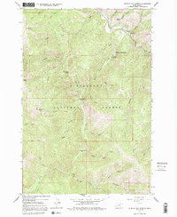
1965 Map of Medicine Hot Springs
USGS Topo · Published 1992About this map
Medicine Hot Springs serves as a thermal landmark within the heavily forested terrain of the Bitterroot National Forest. In the mid-1960s, this portion of Ravalli County was defined by its drainage network, where the East Fork Bitterroot River meets the Bitterroot River near several established recreation sites. The presence of Spring Gulch Campground, Warm Springs Campground, and Crazy Creek Campground indicates a landscape managed for public access and outdoor activity during the post-war era. Significant high points such as Shook Mountain, Medicine Point, and the sharp peak of Jim Hill Rock provide a vertical framework for the অসংখ্য creeks, including Laird Creek and Warm Springs Creek, that carve through the Bitterroot range. The map documents a network of pack trails and jeep trails that provided vital access for forest management and local travel before the expansion of more modern road systems.
Find a feature on this map
46 named features on this map. Tap any name to fly to it.
Don’t see what you’re looking for? This feature index may not catch every label — zoom into the map to look around manually.
Map Details
Editions of this 1965 Medicine Hot Springs Map
3 editions found

Other maps of this area

1955 · Dillon
USGS Topo · 1:250,000

1956 · Elk City
USGS Topo · 1:250,000

1957 · Dillon
USGS Topo · 1:250,000

1958 · Dillon
USGS Topo · 1:250,000

1960 · Elk City
USGS Topo · 1:250,000

1960 · Piquett Mountain
USGS Topo · 1:62,500

1962 · Dillon
USGS Topo · 1:250,000

1964 · Burnt Ridge
USGS Topo · 1:24,000
1964 · Robbins Gulch
USGS Topo · 1:24,000

1964 · Piquett Creek
USGS Topo · 1:24,000