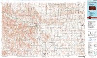
1985 Map of Medicine Lodge
USGS Topo · Published 1990About this map
The Medicine Lodge River carves a winding path through the heart of Barber County, defining a landscape where the Red Hills meet the plains of south-central Kansas. This mid-1980s topographic perspective reveals a series of tight-knit agricultural settlements and rail-reliant towns, including Medicine Lodge, Sun City, and Lake City. The infrastructure of the era is anchored by the Atchison Topeka and Santa Fe railroad, which threads through the southern Tier, connecting Hazelton and Kiowa to the broader regional economy.
Find a feature on this map
95 named features on this map. Tap any name to fly to it.
Don’t see what you’re looking for? This feature index may not catch every label — zoom into the map to look around manually.
Map Details
Editions of this 1985 Medicine Lodge Map
2 editions found
Other maps of this area

1889 · Anthony
USGS Topo · 1:125,000

1889 · Cheney
USGS Topo · 1:125,000

1889 · Caldwell
USGS Topo · 1:125,000

1889 · Kinsley
USGS Topo · 1:125,000

1891 · Medicine Lodge
USGS Topo · 1:125,000

1891 · Cheney
USGS Topo · 1:125,000

1891 · Anthony
USGS Topo · 1:125,000

1892 · Kinsley
USGS Topo · 1:125,000

1892 · Kingman
USGS Topo · 1:125,000

1892 · Coldwater
USGS Topo · 1:125,000