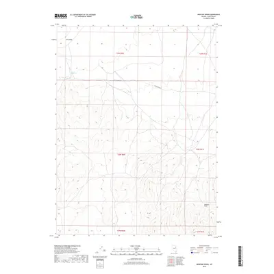
2018 Map of Medicine Spring
USGS Topo · Published 2018About this map
Ruby Valley occupies the northwest corner of this Nevada landscape, transitioning into the elevated terrain of the Medicine Range to the southeast. The quadrangle is defined by its arid hydrology, centered on the historic Medicine Spring and the more southern Mud Spring. These water sources served as critical nodes in a high-desert environment, dictating the path of the original Medicine Spring Rd as it traverses the central valley. The map documents the grid of the Public Land Survey System across Township 28 and 29 North, illustrating how these sections were organized around the few reliable points of water that sustained local ranching and travel in Elko County.
Find a feature on this map
12 named features on this map. Tap any name to fly to it.
Don’t see what you’re looking for? This feature index may not catch every label — zoom into the map to look around manually.
Map Details
Editions of this 2018 Medicine Spring Map
This is the sole edition of this map. No revisions or reprints were ever made.
Other maps of this area

1955 · Elko
USGS Topo · 1:250,000

1958 · Elko
USGS Topo · 1:250,000

1962 · Elko
USGS Topo · 1:250,000

1965 · Elko
USGS Topo · 1:250,000

1968 · Franklin Lake SE
USGS Topo · 1:24,000

1968 · Franklin Lake NE
USGS Topo · 1:24,000

1968 · Ruby Lake NE
USGS Topo · 1:24,000

1984 · West of Delcer Buttes
USGS Topo · 1:24,000
1984 · High Bald Peaks
USGS Topo · 1:24,000

1984 · Delcer Buttes
USGS Topo · 1:24,000