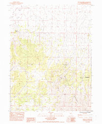
1984 Map of Medicine Spring
USGS Topo · Published 1984About this map
Medicine Spring marks a primary point of interest in this high-desert landscape within Elko County, Nevada. The terrain is dominated by the Medicine Range, which rises dramatically above the eastern edge of the expansive Ruby Valley. This provisional 1984 survey highlights the relationship between the elevated mountain topography and the arid valley floor, emphasizing the natural catchment areas and spring sites that historically dictated land use and travel routes in this part of the Great Basin. The map provides a detailed topographic record of the area's physical relief, showing the steep slopes of the range contrasting with the flatter reaches of the valley.
Find a feature on this map
3 named features on this map. Tap any name to fly to it.
Don’t see what you’re looking for? This feature index may not catch every label — zoom into the map to look around manually.
Map Details
Editions of this 1984 Medicine Spring Map
This is the sole edition of this map. No revisions or reprints were ever made.
Other maps of this area

1955 · Elko
USGS Topo · 1:250,000

1958 · Elko
USGS Topo · 1:250,000

1962 · Elko
USGS Topo · 1:250,000

1965 · Elko
USGS Topo · 1:250,000

1968 · Franklin Lake SE
USGS Topo · 1:24,000

1968 · Franklin Lake NE
USGS Topo · 1:24,000

1968 · Ruby Lake NE
USGS Topo · 1:24,000

1984 · West of Delcer Buttes
USGS Topo · 1:24,000
1984 · High Bald Peaks
USGS Topo · 1:24,000

1984 · Delcer Buttes
USGS Topo · 1:24,000