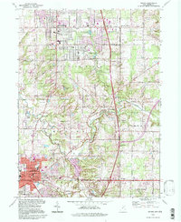
1994 Map of Medina
USGS Topo · Published 1997About this map
Medina and Brunswick anchoring this portion of Medina Co show a landscape of rapid suburban growth alongside enduring agricultural roots. The intersection of major transit corridors is evident at several interchanges, including Interchange 226, which bisects the rolling terrain near Lake Brunswick. Local community life is centered around numerous schools such as Towslee Sch and Applewood Sch, while the area's older history is preserved at Maple Grove Cem and Hamilton Corners Cem.
Find a feature on this map
51 named features on this map. Tap any name to fly to it.
Don’t see what you’re looking for? This feature index may not catch every label — zoom into the map to look around manually.
Map Details
Editions of this 1994 Medina Map
This is the sole edition of this map. No revisions or reprints were ever made.
Other maps of this area

1902 · Berea
USGS Topo · 1:62,500

1903 · Cleveland
USGS Topo · 1:62,500

1903 · Akron
USGS Topo · 1:62,500

1904 · Berea
USGS Topo · 1:62,500

1904 · Medina
USGS Topo · 1:62,500

1905 · Akron
USGS Topo · 1:62,500

1906 · Medina
USGS Topo · 1:62,500

1950 · Cleveland
USGS Topo · 1:250,000

1953 · West View
USGS Topo · 1:24,000

1953 · Broadview Heights
USGS Topo · 1:24,000