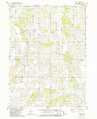
1983 Map of Medora
USGS Topo · Published 1986About this map
The town of Medora sits at the heart of this rural landscape, which spans the intersection of Warren, Clarke, and Lucas counties in the early 1980s. The terrain is defined by a dense network of watercourses including Squaw Creek, Skinaway Creek, and the winding Otter Creek, which carved the undulating topography typical of this part of southern Iowa. Small, established communities like Liberty Center and Cool are connected by a grid of rural avenues such as SW 90th Avenue, while recreational spaces like Hickory Hills County Park provide local landmarks among the agricultural fields.
Find a feature on this map
30 named features on this map. Tap any name to fly to it.
Don’t see what you’re looking for? This feature index may not catch every label — zoom into the map to look around manually.
Map Details
Editions of this 1983 Medora Map
2 editions found
Other maps of this area

1910 · Milo
USGS Topo · 1:62,500

1918 · Chariton
USGS Topo · 1:62,500

1931 · Indianola
USGS Topo · 1:62,500

1950 · New Virginia
USGS Topo · 1:62,500

1952 · New Virginia
USGS Topo · 1:62,500

1954 · Des Moines
USGS Topo · 1:250,000

1956 · Des Moines
USGS Topo · 1:250,000

1957 · Des Moines
USGS Topo · 1:250,000

1965 · Milo
USGS Topo · 1:24,000

1969 · Des Moines
USGS Topo · 1:250,000