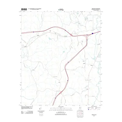
2012 Map of Meehan
USGS Topo · Published 2012About this map
Tunnel Hill and the surrounding piney woods of Lauderdale County are defined by a complex network of small waterways and legacy settlements west of Meridian. The landscape is carved by streams like Cow Creek, Hognose Creek, and the Chunky River, which influence the placement of early crossroads and rural centers. Several small communities, including Lost Gap, Meehan, and Savoy, are linked by the corridor of Old Highway 80 W. Genealogists will find significant value in the distribution of family and community burial grounds, such as Goodwater Cemetery, Osborne Cemetery, and Sageville Cemetery, which are often located near local landmarks like the Tillman Lookout Tower. The eastern edge of the area is marked by the transition toward more developed infrastructure, notably Key Field Airport, illustrating the evolution from a purely timber and agricultural landscape into a modern regional hub.
Find a feature on this map
75 named features on this map. Tap any name to fly to it.
Don’t see what you’re looking for? This feature index may not catch every label — zoom into the map to look around manually.
Map Details
Editions of this 2012 Meehan Map
This is the sole edition of this map. No revisions or reprints were ever made.
Other maps of this area

1921 · Meridian
USGS Topo · 1:48,000

1923 · Meridian
USGS Topo · 1:62,500

1953 · Meridian
USGS Topo · 1:250,000

1957 · Meridian
USGS Topo · 1:250,000

1957 · Chunky
USGS Topo · 1:62,500

1957 · Quitman
USGS Topo · 1:62,500

1957 · Enterprise
USGS Topo · 1:62,500

1965 · Meridian
USGS Topo · 1:250,000

1971 · Meridian South
USGS Topo · 1:24,000

1971 · Meridian North
USGS Topo · 1:24,000