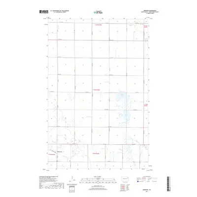
2017 Map of Mekinock
USGS Topo · Published 2017About this map
Mekinock serves as the primary settlement within this section of Grand Forks County, situated along the southern edge of a landscape defined by its agricultural grid and intermittent prairie wetlands. The meandering course of the Turtle River cuts through the southern townships, providing a sharp contrast to the rigid geometry of the surrounding section lines and local roads like Co Rd 11. Further north, the terrain transitions into a series of water bodies and drainage systems, including Stewart Lake and Lumby Lake. These lakes, alongside the engineered path of County Ditch Number 12, illustrate the long-standing efforts to manage the Red River Valley's high water table for productive farming. The map documents the persistent township and range structure, showing how rural life is organized around a network of numbered avenues from 31st Ave NE down to 24th Ave NE.
Find a feature on this map
22 named features on this map. Tap any name to fly to it.
Don’t see what you’re looking for? This feature index may not catch every label — zoom into the map to look around manually.
Map Details
Editions of this 2017 Mekinock Map
This is the sole edition of this map. No revisions or reprints were ever made.
Other maps of this area

1926 · Ardoch
USGS Topo · 1:62,500

1934 · Emerado
USGS Topo · 1:48,000

1934 · Grand Forks
USGS Topo · 1:62,500

1936 · Emerado
USGS Topo · 1:62,500

1938 · Grand Forks
USGS Topo · 1:62,500

1952 · Grand Forks
USGS Topo · 1:250,000

1952 · Thief River Falls
USGS Topo · 1:250,000

1956 · Thief River Falls
USGS Topo · 1:250,000

1956 · Grand Forks
USGS Topo · 1:250,000

1957 · Thief River Falls
USGS Topo · 1:250,000