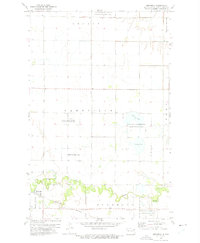
1973 Map of Mekinock
USGS Topo · Published 1975About this map
Mekinock serves as a central hub in this Red River Valley landscape, where the Burlington Northern railroad cuts through the southern reaches near the Turtle River. The map reveals a community structured around its local institutions, including the Mekinock Sch and Ness Ch, which stood alongside the rail line during this mid-1970s period. Significant portions of the land are dedicated to conservation, notably the multiple sections of the Prairie Chicken State Game Management Area and the National Waterfowl Production Area surrounding Stewart Lake and Lunby Lake. This pattern of land use illustrates the region's commitment to preserving native prairie habitats amidst a highly organized agricultural grid. Further east, the Middle Grove Ch and a nearby Cem mark the rural township of Ferry, reflecting the scattered settlement patterns of Grand Forks County.
Find a feature on this map
17 named features on this map. Tap any name to fly to it.
Don’t see what you’re looking for? This feature index may not catch every label — zoom into the map to look around manually.
Map Details
Editions of this 1973 Mekinock Map
This is the sole edition of this map. No revisions or reprints were ever made.
Other maps of this area

1926 · Ardoch
USGS Topo · 1:62,500

1934 · Emerado
USGS Topo · 1:48,000

1934 · Grand Forks
USGS Topo · 1:62,500

1936 · Emerado
USGS Topo · 1:62,500

1938 · Grand Forks
USGS Topo · 1:62,500

1952 · Grand Forks
USGS Topo · 1:250,000

1952 · Thief River Falls
USGS Topo · 1:250,000

1956 · Thief River Falls
USGS Topo · 1:250,000

1956 · Grand Forks
USGS Topo · 1:250,000

1957 · Thief River Falls
USGS Topo · 1:250,000