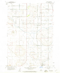
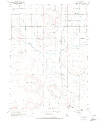
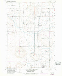
1958 Map of Melba
USGS Topo · Published 1960About this map
Bowmont and Melba anchor the agricultural landscape of the Snake River Valley south of Nampa in the late 1950s. The region is defined by a sophisticated water management system designed by the U.S. Bureau of Reclamation, featuring the Mora Canal, Waldvogel Canal, and a notable Siphon Flume. These irrigation works transformed Upper Deer Flat into productive farmland, supported by the Union Pacific Railroad which bisects the quadrangle.
Find a feature on this map
54 named features on this map. Tap any name to fly to it.
Don’t see what you’re looking for? This feature index may not catch every label — zoom into the map to look around manually.
Map Details
Editions of this 1958 Melba Map
3 editions found
Other maps of this area

1892 · Boise
USGS Topo · 1:125,000

1892 · Bisuka
USGS Topo · 1:125,000

1892 · Silver City
USGS Topo · 1:125,000

1894 · Bisuka
USGS Topo · 1:125,000

1894 · Silver City
USGS Topo · 1:125,000

1897 · Boise
USGS Topo · 1:125,000

1898 · Nampa
USGS Topo · 1:125,000

1898 · Silver City
USGS Topo · 1:125,000

1953 · Meridian
USGS Topo · 1:24,000

1955 · Boise
USGS Topo · 1:250,000