1958 Map of Melba
USGS Topo · Published 1985About this map
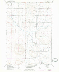
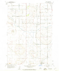
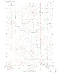
Upper Deer Flat defines the northwestern reaches of this Idaho landscape, where the Union Pacific Railroad cuts a north-south path through the high desert of Canyon County. The terrain is dominated by prominent volcanic rises including Hat Butte, Mc Elroy Butte, and the Madden formation, while a complex network of man-made irrigation features like the Mora Lateral and Melba Lateral reveals the agricultural transformation of the Snake River Valley. Small rural hubs and junctions such as Bowmont, Melmont, and Melba are anchored by essential community structures like the Scism School and Happy Valley School. This 1958 survey, updated with 1971 aerial observations, illustrates the intersection of heavy rail infrastructure and the Bureau of Reclamation's water distribution systems, showing how the desert was partitioned by names like Scism Road and Pass Road to support a growing farming economy.
Find a feature on this map
55 named features on this map. Tap any name to fly to it.
Don’t see what you’re looking for? This feature index may not catch every label — zoom into the map to look around manually.
Map Details
Editions of this 1958 Melba Map
3 editions found
Other maps of this area

1892 · Boise
USGS Topo · 1:125,000

1892 · Bisuka
USGS Topo · 1:125,000

1892 · Silver City
USGS Topo · 1:125,000

1894 · Bisuka
USGS Topo · 1:125,000

1894 · Silver City
USGS Topo · 1:125,000

1897 · Boise
USGS Topo · 1:125,000

1898 · Nampa
USGS Topo · 1:125,000

1898 · Silver City
USGS Topo · 1:125,000

1953 · Meridian
USGS Topo · 1:24,000

1955 · Boise
USGS Topo · 1:250,000