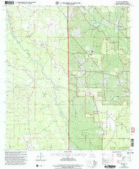
2003 Map of Melder
USGS Topo · Published 2005About this map
The Calcasieu River meanders through this landscape of the central Louisiana piney woods, defining a terrain shaped by the Kisatchie National Forest. This 2003 revision reveals a network of rural life anchored by community landmarks such as Union Hill Ch and Peniel Ch, alongside family-named sites like Stanley Cem. The map documents a blend of conservation and industrial land use, featuring the Palustris Experimental Forest (Longleaf Tract) and several Gravel Pits that suggest a reliance on local mineral resources. Strategic points such as the Sunset Lookout Tower overlook a dense system of waterways including Blounts Creek and Spring Creek, while the Base Line serves as a primary survey marker for the region's property boundaries.
Find a feature on this map
32 named features on this map. Tap any name to fly to it.
Don’t see what you’re looking for? This feature index may not catch every label — zoom into the map to look around manually.
Map Details
Editions of this 2003 Melder Map
This is the sole edition of this map. No revisions or reprints were ever made.
Other maps of this area

1935 · Pawnee
USGS Topo · 1:31,680

1942 · Oakdale
USGS Topo · 1:62,500

1943 · Leander
USGS Topo · 1:62,500

1947 · Steep Gully
USGS Topo · 1:31,680

1949 · Glenmora
USGS Topo · 1:31,680

1951 · Steep Gully
USGS Topo · 1:24,000

1952 · Lake Charles
USGS Topo · 1:250,000

1953 · Alexandria
USGS Topo · 1:250,000
1954 · Pawnee
USGS Topo · 1:31,680
1954 · Leander
USGS Topo · 1:62,500