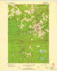
1956 Map of Mellen
USGS Topo · Published 1958About this map
The town of Mellen serves as the hub of this 1950s survey, positioned at the confluence of the Bad River and Montreal River. The landscape is heavily defined by its recreational and natural resources, featuring the northern boundaries of the Chequamegon National Forest and the diverse topography of Copper Falls State Park. North of the town center, the Mellen Country Club and a Powerplant on the river indicate the local infrastructure of the mid-century era.
Find a feature on this map
30 named features on this map. Tap any name to fly to it.
Don’t see what you’re looking for? This feature index may not catch every label — zoom into the map to look around manually.
Map Details
Editions of this 1956 Mellen Map
This is the sole edition of this map. No revisions or reprints were ever made.
Other maps of this area

1942 · Glidden
USGS Topo · 1:48,000

1942 · Clam Lake
USGS Topo · 1:48,000

1942 · Mellen
USGS Topo · 1:48,000

1942 · Marengo
USGS Topo · 1:48,000

1945 · Marengo
USGS Topo · 1:48,000

1945 · Clam Lake
USGS Topo · 1:48,000

1945 · Glidden
USGS Topo · 1:48,000

1945 · Mellen
USGS Topo · 1:48,000

1953 · Ashland
USGS Topo · 1:250,000
1956 · Mt. Whittlesey
USGS Topo · 1:24,000