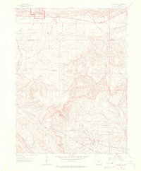
1962 Map of Mellen Hill
USGS Topo · Published 1965About this map
Coal Oil Basin and the adjacent Raven Ridge characterize this high-desert landscape in northwestern Colorado during the early 1960s. The map captures a transition between protected wilderness and industrial activity, with the southern boundary of Dinosaur National Monument clipping the northwest corner, while the Rangel Field and an extensive Pipeline network dominate the southern sections. This era of resource extraction is marked by infrastructure like the Raven Radio Tower and a remote Landing Strip situated near Dripping Rock Creek. Seasonal water management is evident through features such as Dripping Rock Reservoir, while the presence of numerous jeep trails suggests a terrain navigated by work crews and surveyors. The boundary between Moffat and Rio Blanco counties bisects the northern half of the sheet, cutting across drainage systems like Twin Wash and Spencer Draw.
Find a feature on this map
18 named features on this map. Tap any name to fly to it.
Don’t see what you’re looking for? This feature index may not catch every label — zoom into the map to look around manually.
Map Details
Editions of this 1962 Mellen Hill Map
This is the sole edition of this map. No revisions or reprints were ever made.
Other maps of this area

1885 · Ashley
USGS Topo · 1:250,000

1907 · Rangely
USGS Topo · 1:125,000

1907 · Jensen
USGS Topo · 1:125,000

1910 · Jensen
USGS Topo · 1:125,000

1910 · Rangely
USGS Topo · 1:125,000

1954 · Vernal
USGS Topo · 1:250,000

1958 · Vernal
USGS Topo · 1:250,000

1960 · Vernal
USGS Topo · 1:250,000

1962 · Lazy Y Point
USGS Topo · 1:24,000

1962 · Rangely NE
USGS Topo · 1:24,000