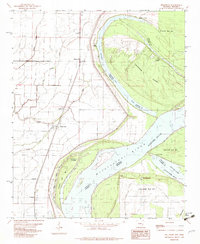
1982 Map of Mellwood
USGS Topo · Published 1982About this map
Mississippi River dynamics dominate this portion of the Arkansas-Mississippi border, where the shifting channel has left behind a complex network of chutes and oxbows. The settlement of Mellwood serves as a central point for a landscape defined by industrial and agricultural transport, evidenced by the presence of Mosby Spur and the rail line connecting Lundell, Crumrod, and Ferguson. The map records a series of distinct river landings including Dawson Landing, Reese Landing, and Ludlow Landing, highlighting the historic importance of water-based commerce along this stretch of the Delta.
Find a feature on this map
30 named features on this map. Tap any name to fly to it.
Don’t see what you’re looking for? This feature index may not catch every label — zoom into the map to look around manually.
Map Details
Editions of this 1982 Mellwood Map
This is the sole edition of this map. No revisions or reprints were ever made.
Other maps of this area

1930 · Mellwood
USGS Topo · 1:62,500

1939 · Modoc
USGS Topo · 1:62,500

1939 · Indian Bay
USGS Topo · 1:62,500

1939 · Henrico
USGS Topo · 1:62,500

1939 · Mellwood
USGS Topo · 1:62,500

1948 · Helena
USGS Topo · 1:250,000

1948 · Modoc
USGS Topo · 1:62,500

1950 · Helena
USGS Topo · 1:250,000

1954 · Mellwood
USGS Topo · 1:62,500

1954 · Indian Bay
USGS Topo · 1:62,500