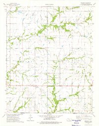
1974 Map of Melrose
USGS Topo · Published 1975About this map
The Old Indian Treaty Boundary bisects this Cherokee County landscape, marking a historical line across the rural townships of Lola, Salamanca, Neosho, and Lyon. In the mid-1970s, this area near the Oklahoma border remained deeply agricultural, anchored by the small settlement of Melrose and the nearby community of Keelville. The landscape is defined by the winding paths of Fly Creek, Squaw Creek, and Fourmile Creek, which create natural corridors through the surveyed grid of section lines.
Find a feature on this map
22 named features on this map. Tap any name to fly to it.
Don’t see what you’re looking for? This feature index may not catch every label — zoom into the map to look around manually.
Map Details
Editions of this 1974 Melrose Map
This is the sole edition of this map. No revisions or reprints were ever made.
Other maps of this area

1886 · Joplin
USGS Topo · 1:125,000

1886 · Parsons
USGS Topo · 1:125,000

1893 · Parsons
USGS Topo · 1:125,000

1894 · Joplin
USGS Topo · 1:125,000

1901 · Vinita
USGS Topo · 1:125,000

1907 · Wyandotte
USGS Topo · 1:125,000

1909 · Wyandotte
USGS Topo · 1:125,000

1913 · Vinita
USGS Topo · 1:125,000

1918 · Columbus
USGS Topo · 1:62,500

1944 · Oswego
USGS Topo · 1:62,500