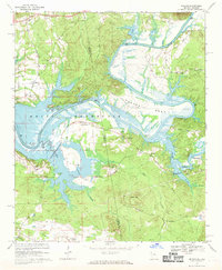
1967 Map of Melson
USGS Topo · Published 1969About this map
The Coosa River meanders through this borderland between Alabama and Georgia, its path reshaped by the rising waters of the Weiss Reservoir. In the late 1960s, the landscape is defined by the tension between the new reservoir's controlled inundation zones and the established rural settlements of Kirks Grove and Melson. The map captures a detailed network of country churches and family burial grounds, such as Old Nazareth Ch and the Clemons Cem, which stand as landmarks for local genealogy. Industrial activity is visible in several Gravel Pits and the lingering path of the Old RR Grade, while the rugged river bends like Foster Bend and Mc Gee Bend dictate the local road patterns. Moving south of Heath Mtn, the terrain transitions into the creek-fed valleys of Mud Creek and Kanady Creek, highlighting a way of life oriented toward the river's edge before modern development reached these quiet bends.
Find a feature on this map
46 named features on this map. Tap any name to fly to it.
Don’t see what you’re looking for? This feature index may not catch every label — zoom into the map to look around manually.
Map Details
Editions of this 1967 Melson Map
2 editions found
Other maps of this area

1886 · Rome
USGS Topo · 1:125,000

1893 · Fort Payne
USGS Topo · 1:125,000

1898 · Rome
USGS Topo · 1:125,000

1898 · Fort Payne
USGS Topo · 1:125,000

1899 · Rome
USGS Topo · 1:125,000

1900 · Fort Payne
USGS Topo · 1:125,000

1904 · Rome
USGS Topo · 1:125,000

1955 · Rome
USGS Topo · 1:250,000

1958 · Rome
USGS Topo · 1:250,000

1961 · Rome
USGS Topo · 1:250,000