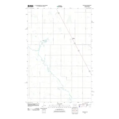
2011 Map of Melville
USGS Topo · Published 2011About this map
Melville serves as the primary settlement on this Foster County landscape, situated along a prominent transit corridor that cuts diagonally across the prairie. The surrounding terrain is defined by the wandering path of Pipestem Creek, which meanders through the central and southern portions of the quadrangle. North of the creek, the Melville Dam creates the waters of Lake Bonita, a significant local landmark. The area is organized by a systematic grid of township roads, including 67th Ave SE and 4th St SE, which facilitate access to the surrounding agricultural land and the various small water bodies scattered across the northern sections. This 2011 survey illustrates the rural character of the region, where the intersection of water management and transportation infrastructure remains central to the local economy.
Find a feature on this map
20 named features on this map. Tap any name to fly to it.
Don’t see what you’re looking for? This feature index may not catch every label — zoom into the map to look around manually.
Map Details
Editions of this 2011 Melville Map
This is the sole edition of this map. No revisions or reprints were ever made.
Other maps of this area

1900 · Pingree
USGS Topo · 1:125,000

1900 · Pingree
USGS Topo · 1:62,500

1948 · Carrington
USGS Topo · 1:62,500

1950 · Carrington East
USGS Topo · 1:24,000

1950 · Melville
USGS Topo · 1:24,000

1950 · Carrington SW
USGS Topo · 1:24,000

1950 · Carrington West
USGS Topo · 1:24,000

1951 · Pingree
USGS Topo · 1:24,000

1951 · Bordulac SW
USGS Topo · 1:24,000
1951 · Bordulac
USGS Topo · 1:24,000