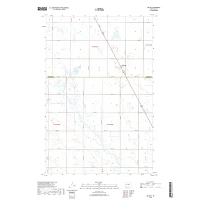
2018 Map of Melville
USGS Topo · Published 2018About this map
Melville stands at a central junction in this prairie landscape, where the diagonal path of US Highway 281 meets a grid of rural section roads. The terrain is defined by the glacial depressions and wetlands characteristic of the region, most notably Lake Bonita and the winding course of Pipestem Creek which meanders through the southern half of the quadrangle. The map documents the boundary between Foster Co and Stutsman Co, illustrating how the political lines of t145n r66w and t144n r66w intersect with the natural drainage patterns of the Dakota plains. This 2018 survey provides a clear view of the sparse residential footprint and the vast wetland inventory that dictates the agricultural layout of the area.
Find a feature on this map
23 named features on this map. Tap any name to fly to it.
Don’t see what you’re looking for? This feature index may not catch every label — zoom into the map to look around manually.
Map Details
Editions of this 2018 Melville Map
This is the sole edition of this map. No revisions or reprints were ever made.
Other maps of this area

1900 · Pingree
USGS Topo · 1:125,000

1900 · Pingree
USGS Topo · 1:62,500

1948 · Carrington
USGS Topo · 1:62,500

1950 · Carrington East
USGS Topo · 1:24,000

1950 · Melville
USGS Topo · 1:24,000

1950 · Carrington SW
USGS Topo · 1:24,000

1950 · Carrington West
USGS Topo · 1:24,000

1951 · Pingree
USGS Topo · 1:24,000

1951 · Bordulac SW
USGS Topo · 1:24,000
1951 · Bordulac
USGS Topo · 1:24,000