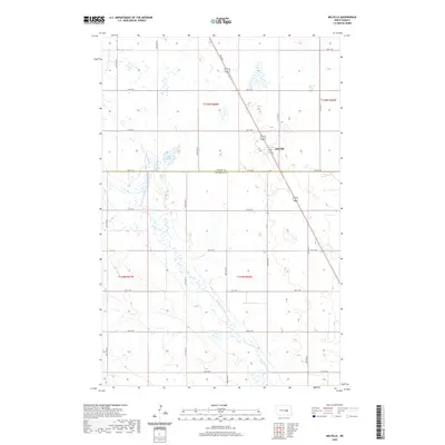
2020 Map of Melville
USGS Topo · Published 2020About this map
Melville sits at the intersection of local travel routes along the northern edge of this North Dakota landscape, where the prairie is defined by the winding course of Pipestem Creek. The creek meanders southward from Lake Bonita, crossing the political boundary between Foster Co and Stutsman Co. This survey reflects the characteristic township and range grid system of the Great Plains, with roads like 4th Ave S and 6th St SE providing the structural framework for the rural agricultural economy. The terrain is dotted with numerous small wetlands and depressions typical of the regional glacial geology, interspersed with the strictly linear road network that connects isolated farmsteads to the central hub at Melville.
Find a feature on this map
18 named features on this map. Tap any name to fly to it.
Don’t see what you’re looking for? This feature index may not catch every label — zoom into the map to look around manually.
Map Details
Editions of this 2020 Melville Map
This is the sole edition of this map. No revisions or reprints were ever made.
Other maps of this area

1900 · Pingree
USGS Topo · 1:125,000

1900 · Pingree
USGS Topo · 1:62,500

1948 · Carrington
USGS Topo · 1:62,500

1950 · Carrington East
USGS Topo · 1:24,000

1950 · Melville
USGS Topo · 1:24,000

1950 · Carrington SW
USGS Topo · 1:24,000

1950 · Carrington West
USGS Topo · 1:24,000

1951 · Pingree
USGS Topo · 1:24,000

1951 · Bordulac SW
USGS Topo · 1:24,000
1951 · Bordulac
USGS Topo · 1:24,000